abstract:
Domestically, yesterday, heavy rain or heavy rain occurred in parts of Beijing-Tianjin-Hebei, Henan, Shanxi, Shandong and other places, and local heavy rain occurred. It is expected that in the next three days, Beijing-Tianjin-Hebei, Shandong, Shanxi and other places will have high risk of rainstorm disasters, and pay attention to possible flash floods, geological disasters, urban and rural waterlogging and strong convection hazards.
Globally, in the past 24 hours, heavy rainfall occurred in central India and other places, and high temperatures continued in southern Europe and the southern United States. In the next three days, there will be heavy rainfall in central and southern India, and the high temperature in the United States and Mexico will continue.
I. Domestic weather conditions
1. Reality
From 08: 00 to 06: 00 yesterday, there were heavy rains or heavy rains in parts of southern Beijing, southern Tianjin, central and southern Hebei, central and northern Henan, southeastern Shanxi, western Shandong, eastern Liaoning and southwestern Anhui, southern Hubei, coastal Zhejiang, northwestern Fujian and coastal Guangdong, and heavy rains (250-350 mm) in Shijiazhuang, Xingtai, Handan, Henan Xinxiang and other places, Xingtai, Hebei. The maximum hourly rainfall in some of the above areas is 40 ~ 90 mm, and the local areas in Yichang, Hubei and Guangzhou, Guangdong are 100 ~ 117 mm; In addition, thunderstorms and strong winds occurred in Heilongjiang, Shandong, Anhui, Zhejiang, Fujian and other places, and hail occurred in Shandong.
2. Key weather forecast
(1) There are heavy rainfall and strong convective weather in Beijing, Tianjin and Hebei.
From July 30 to 31, there were heavy rains in northern Henan, western Shandong, Hebei, central and eastern Shanxi, Beijing, Tianjin and central Inner Mongolia, among which there were heavy rains in parts of eastern Shanxi, central and southern Hebei, Beijing and western Tianjin, and heavy rains in parts of mountainous areas in central and southern Hebei and southern Beijing, accompanied by strong convective weather such as short-term heavy precipitation and thunderstorms.
It is estimated that there will be heavy rains in Hebei, Beijing, Tianjin, central and eastern Shanxi, northern Henan, central and western Shandong from 08: 00 on July 30 to 08: 00 on July 31, among which there will be heavy rains in parts of central and southern Hebei, central and southern Beijing, western Tianjin, eastern Shanxi and other places, and heavy rains (250-400 mm) in parts of central Hebei and southwestern Beijing. There is heavy rain or rainstorm in parts of central Anhui, eastern and southern Hubei, northern Hunan, northern Guizhou, southwestern Yunnan and northern Jilin (see Figure 1). Some of the above areas are accompanied by short-term heavy rainfall (the maximum hourly rainfall is 30-70 mm, and the local area can exceed 100 mm). Some areas in southeastern Heilongjiang, central Jilin, central and southern Hebei, southern Beijing, Tianjin, central and southwestern Shandong, southern and northeastern Henan, western and northeastern Anhui, central and northern Jiangsu, eastern Hubei, northwestern Jiangxi, and western Zhejiang will have 8-10 grades and local areas. The Central Meteorological Observatory continued to issue red rainstorm warning and yellow severe convective weather warning at 06: 00 on July 30.
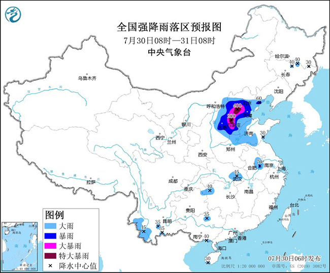
Fig. 1 Forecast Map of Heavy Rainfall in China (08: 00 on July 30-08: 00 on July 31)
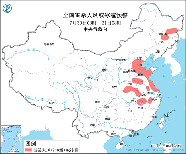
Figure 2 National Thunderstorm Gale or Hail Warning (08: 00 on July 30-08: 00 on July 31)
In addition, due to the influence of Typhoon Kanu, there will be strong wind and rain in the southeast sea and coastal areas from August 1 to 4, and there will be heavy rain in Jiangnan and eastern South China, and heavy rain in the local area.
From August 2 nd to 5 th, there was a lot of rain in the northeast, some of which were moderate to heavy rain, and there was heavy rain or heavy rain in the local area.
In the next 10 days, there will be another typhoon in the Pacific Northwest.
Second, the global weather situation
1. Reality
(1) Heavy rainfall occurred in central India and other places.
In the past 24 hours, there have been moderate to heavy rains in the southwest of the Far East, Japan, the Philippine Islands, the northern and southern coastal areas of Indo-China Peninsula, central India, south-central Pakistan, Ukraine, western Russia, the Great Caucasus, the Great Lakes region, the eastern United States, and south-central Mexico, with local heavy rains to heavy rains.
(2) The continuous high temperature in southern Europe and the southern United States.
In northern Africa, West Asia, southwestern Central Asia, central Pakistan, southwestern Russia, south-central United States, northern Mexico and other places, high temperature weather above 37℃ occurred, and the daily maximum temperature in some areas exceeded 42℃, among which the maximum temperature in southern Arizona in the United States exceeded 45℃.
2. Key weather forecast
(1) There is heavy rainfall in central and southern India.
Affected by the vortex and the southwest monsoon, there are moderate to heavy rains in the south-central Indian Peninsula, western and southern Myanmar, among which there are heavy rains in the central and southwest coastal areas of the Indian Peninsula and the southeast coastal areas of Myanmar.
(2) The high temperature in America, Mexico and other places will continue.
Affected by the unusually strong subtropical high belt, the hot weather in the central and southern United States, central and northern Mexico, northern Africa, West Asia, central and southern Central Asia, and northwestern South Asia will continue in the next three days. The highest temperature in these areas is generally above 37 C, and the local highest temperature can reach above 45 C. There are still high temperatures above 35℃ in central and southern Spain, Sardinia, Italy, Sicily and Greece.
Third, the domestic specific forecast for the next three days
From 08: 00 on July 30 to 08: 00 on July 31, there were heavy rains in Hebei, Beijing, Tianjin, central and eastern Shanxi, northern Henan, and central and western Shandong. Among them, there were heavy rains in parts of central and southern Hebei, central and southern Beijing, western Tianjin, and eastern Shanxi, and heavy rains (250-400 mm) in parts of central Hebei and southwestern Beijing. There is heavy rain or rainstorm in parts of central Anhui, eastern and southern Hubei, northern Hunan, northern Guizhou, southwestern Yunnan and northern Jilin (see Figure 3). There are 4 ~ 6 winds in parts of central and eastern North China, eastern Huanghuai and northeastern Jiangnan.
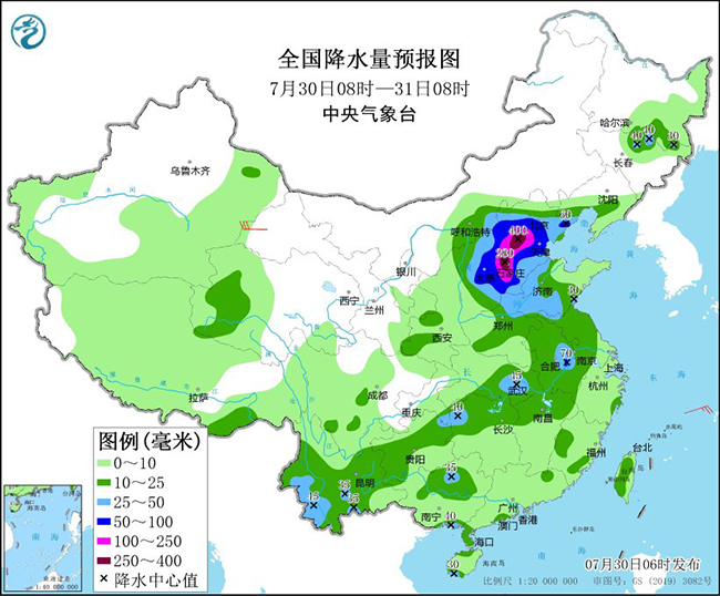
Figure 3 National Precipitation Forecast Chart (08: 00 on July 30th-08: 00 on July 31st)
From 08: 00 on July 31 to 08: 00 on August 1, there were heavy rainstorms in parts of south-central Inner Mongolia, most of Hebei, Beijing, Tianjin, northern and central Henan, southern Hubei, northern Hunan and southern Sichuan Basin, among which there were heavy rainstorms (100-160 mm) in central Hebei and southwestern Beijing (see Figure 4). There are 4 ~ 6 winds in parts of Liaodong Peninsula, Shandong Peninsula and northeastern Jiangnan. In the southern part of the East China Sea, there are 6 ~ 7 northeast winds with 8 gusts and 10 ~ 11 rotating winds with 12 gusts.
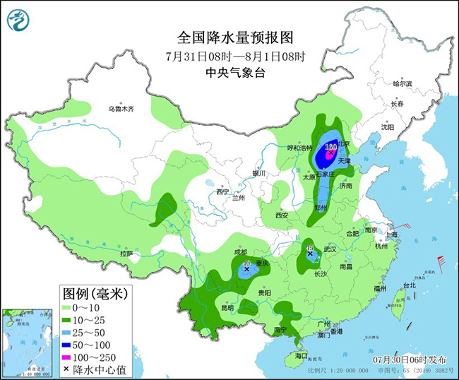
Figure 4 National Precipitation Forecast Chart (08: 00 on July 31st-08: 00 on August 1st)
From 08: 00 on August 1 to 08: 00 on August 2, there were moderate to heavy rains in parts of central Inner Mongolia, central Jilin, western Guizhou, western Guangxi, Yunnan and eastern Zhejiang, with local heavy rain (50-65 mm) (see Figure 5). There are 4 ~ 6 winds in parts of Shandong Peninsula and eastern Jiangnan, and the winds in parts of eastern Zhejiang can reach more than 7. In the south of the East China Sea, there are 12-13 winds with gusts of 14, and in the north of the East China Sea, there are 8-10 winds with gusts of 11.
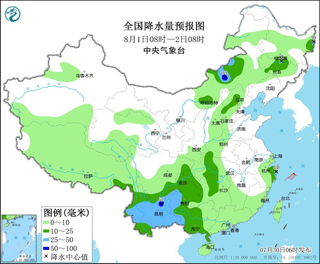
Figure 5 National Precipitation Forecast Chart (08: 00 August 1-08: 00 August 2)
(Editor: Su Jessie)
关于作者